Atchafalaya Basin Master Plan for Flood Protection, Ecological Enhancement, Wetland Protection, and Coastal Restoration
Atchafalaya Basinkeeper, Gulf Restoration Network, Louisiana Crawfish Producers Association-West and Sierra Club Delta Chapter
Introduction
Floodplains are critical for flood protection, even more so in southern Louisiana than in most places in the country. Good water management and floodplain protection is crucial for future generations to live safely in southern Louisiana, and enjoy the same natural world that we enjoy today. Ultimately we are borrowing these natural resources for generations to come.
When floodplains disappear, their ability to absorb floodwaters is lost. Whether filling in the floodplains of the Atchafalaya Basin to create uplands, or building a levee to isolate the Basin, the effect is the same. The way that the Atchafalaya Basin (and the rest of coastal Louisiana) is being managed is unsustainable. As a result, we are destroying an irreplaceable ecosystem, and with it, ecosystem services that are integral to preventing flood disasters today and in the future.
When our levees work against us
The Atchafalaya Basin Spillway (or simply Spillway) illustrates how levees can intensify flooding in surrounding areas. The Spillway was designed by the Corps of Engineers to protect people and property from the flooding of the Mississippi River.
The ability of the Atchafalaya Spillway to absorb floods is immense. During the great flood of August 2016 Grand River at Bayou Sorrel crested August 17,2016, at 10.39, but the Spillway across the levee at the Bayou Sorrel Locks crested three days earlier, August14, 2016, at only 7.1’. Ongoing research conducted by Atchafalaya Basinkeeper on a property in the Iberville Parish community of Bayou Sorrel, recorded that during that flood the yard at the site of research was about 1.39 feet under water and the elevated house was about 1.6 feet above water. Without the levees that yard would have been about 1.5 feet above water. This is an instance where levees created a flood rather than preventing one.
In contrast, in 2011 the water stage inside the Spillway at Bayou Sorrel crested at 17.4 feet; without the levees that same house would have been more than 5 feet under water. Levees are built for flood protection; however, they can also be responsible for transforming our towns and cities into floodplains by preventing drainage into rivers and other natural waterways.
The Atchafalaya “Spillway” today
The Atchafalaya Basin Spillway is incredibly important for Louisiana, the nation, and the ecology of our planet. It contains the largest river swamp in North America. Producing the single largest wild harvest of crawfish in the world, the Atchafalaya Basin’s swamps are considered to be the most productive wetlands on Earth. It is the last bastion of our Cajun culture. Situated at the doorway of the Mississippi Flyway, the Atchafalaya Basin is arguably the single most important ecosystem for migratory birds in the Western Hemisphere. It is a critical habitat for rich and diverse variety of wildlife, including threatened and endangered species. In a land of vanishing wetlands and sinking coast, the Atchafalaya Basin provides the only growing delta in the state.
As important as the Atchafalaya Basin is for ecological values, we must not forget that the Basin is also a spillway that is critical for flood control. As the Basin's swamps, lakes and bayous become uplands, the flooding capacity of the Basin is being compromised. Since 1932, there has been a net accretion of nearly 2.5 billion cubic meters of sediment in the Basin floodway, converting a substantial amount of open water and cypress swamps to bottomland hardwood forests. This greatly reduces the ability of the Spillway to handle floodwaters.
With responsible management, we could increase the ability of the Basin to handle floods inside and outside of the levees, build more land along the coast, and improve water quality and seafood production.
A holistic management plan for the Atchafalaya Basin Spillway
Holistic sustainable management of the Atchafalaya Basin should have three components:
1. Hydrology should be restored, as near as possible, to its original state (before levees were built) to allow the Spillway to capture floodwaters from both sides of the levees, thereby protecting communities from river flooding, as well as flooding from local rains. This would improve water quality, wildlife habitat, and ultimately seafood production.
2. Sediments should be managed and contained in the main river channel, away from swamps, lakes and bayous, to maintain the floodplain’s ability to handle floodwaters, protect critical wetland habitat, and rebuild our coast.
3. The management design should be done in such a way as to preserve the ecosystem, thus maximizing natural ecosystem services such as sustainable flood protection.
Pumps versus channels and locks
Water pumps do not provide any significant ecological benefits to the Atchafalaya Basin and the communities who depend on the Basin’s resources. Fish and shellfish cannot freely navigate through the pumps. Pumps can be also very expensive to operate and maintain.
In contrast, building channels to reconnect waterways could have extensive ecological benefits. These channels would allow fish and shellfish to migrate throughout the Basin, expanding the productivity of the entire Basin to the rest of coastal Louisiana. Channels and locks also allow natural systems to operate, exchanging nutrients and improving water quality. People could again navigate by boat into and out of the Atchafalaya Basin for fishing and recreation, which could ultimately promote ecotourism.
Water pumps could be strategically installed in addition to the channels, to provide additional protection, in the event of a flood during our annual high water season.
Here, by aerial photographs and added text, is an explanation of how the Atchafalaya Basin could be restored in a way that would protect South Louisiana from future flooding. This restoration plan would also protect the Basin from further destruction, as well as increase its productivity and environmental health. Suggested changes are marked in blue and red.
Restoration of hydrology for flood protection and ecological enhancement


Grand River to Grand River connection and lock.

Locks should be kept open at low river stages; they should be closed for flood protection and sediment management during high river stages.

Cross Bayou to Spillway connection and lock. To be left open; closed only during high river stages.

Bayou Pigeon-Grand River connection and lock. To be left open; closed only during high river stages.

Old River-Belle River connection and lock. To be left open; closed only during high river stages.

Lower Bayou Sorrel-Belle River connection and lock. To be left open; closed only during high river stages.
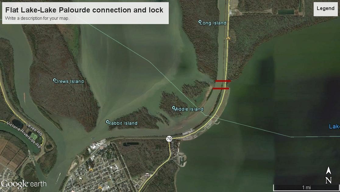
Flat Lake-Lake Palourde connection and lock. To be left open; closed only during high river stages.

Lake Fausse Point-Grand Lake connection and lock. To be left open; closed only during high river stages.

Lake Dauterive-Bayou Benoit connection and lock. To be left open; closed only during high river stages.

Bayou Amy-Henderson Lake connection and lock. To be left open until needed for flood control.

Bayou Courtableau lock. To be left open until needed for flood control.
Atchafalaya Basin floodplain sediment management plan for flood and ecological services protection and coastal restoration
LIDAR showing accretion problem in the Atchafalaya Basin.

Whiskey Bay/Atchafalaya River sediment guide weir.

To keep bedload in the main channel away from the Basin's swamps, lakes and bayous. Sediment trap to capture and dispose sand back in channel.
Closure of Grand River to be replaced by reopening Tensas
The realignment of Grand River in 1994 greatly increased sand and sediments in wetlands with significant negative effects to the hydrology of the floodplain, and ecological services. Sediment trap to be managed by disposing sand in channel.


Bayou Sorrel restoration. Bayou Sorrel cut closure, restoring Jakes Bayou, sediment guide weir and sediment trap.
The realignment and straightening of Bayou Sorrel and the closure of Jakes Bayou around 1969-1970 increased bedload and sediments moving into Bayou Sorrel with significant negative effects to the hydrology of the floodplain, and ecological services. This needs to be reversed. Sand should be guided to stay in the main channel of the river, and sand from the river into the bayou should thereby be reduced. Sediment trap should be managed by depositing sand back in channel.


Bayou Chene restoration. Bayou Chene cut closure, restoring old Bayou Chene, sediment guide weir and sediment trap.
Bayou Chene was dammed around 1989, and flows from the river were diverted through a new straight cut at the end of a river bend. This increased sand distribution and sediments into the bayou with significant negative effects to the hydrology of the floodplain and ecological services. Sand should be guided to stay in the main river, and sand load from the river should be reduced. Sediment trap should be managed by depositing sand back in channel.


Coon Trap closure
Coon trap was opened in the early 1990s serving as a direct route for sand and silt into different bayous and Grand Lake, which resulted in the silting of hundreds of acres of swamps. Coon Trap closed 2021. This closure needs to be maintained.

Blue point Chute sediment guide weir
Sediments moving down Blue Point Chute have resulted in the rapid filling of open water and swamps. Sand should be guided to remain in the main Atchafalaya River channel. Sediment trap should be managed by depositing sand back in channel.

Canal into Bayou Boutte closure
This canal brings vast quantities of sand and silt to Bayou Boutte and the Duck Lake area. Energy XXI made a major investment to restore Bayou Boutte; however, the effects of this restoration were temporary, and the bayou is again accumulating detrimental levels of silt. The canal provides a convenient short-cut, which some would prefer to maintain despite the damage it causes to the ecological health of the Basin. The area can be accessed through Blue Point Chute or American Pass.

Closure of oil canal into American Lake area
This canal brings sediments into the Bayou Boutte-American Lake area, and must be closed to protect the floodplain and wetland ecosystems.


American Pass sediment protection weirs 1 & 2. Sediment traps
Sediments from the Atchafalaya River are seriously affecting American Pass and the Flat Lake area. These 2 sediment guide weirs should be built to alleviate this issue. Sediment traps should be managed by depositing sand back in channel.

Sand/sediment mining for Unlimited Material for Coastal Restoration
We are proposing to build one or two sediment transport pipelines from Lower Grand Lake/Six Mile Lake, Flat Lake and Lake Palourde above Morgan City, to strategic spots on the coast and suction dredge what used to be the bed on Grand Lake, Flat Lake and Lake Palourde to its original depths, transporting the sand and silt toward the coast to be used for coastal restoration. After Grand Lake is restored, the bed of Grand Lake will become a huge sediment trap where sand and silt can be mined forever, year after year. Enough sediment will be going through to keep the Atchafalaya Delta healthy and it will be a huge help for the Port of Morgan City and navigation by limiting or eliminating the need for dredging needed to keep the port open all year round.

Conclusion
We have something that no one else has, and that can never be re-created. Once it is gone, it is gone forever. The Atchafalaya Basin is of critical importance to the ecosystem and wildlife of the entire western hemisphere; and because of its beauty, ecological values, and ecosystem services including flood protection, it is a vital asset for future generations here in Louisiana and humanity as a whole.
Louisiana should not be using public funds to fill valuable wetlands located far away from the coast. We are complaining about the loss of our coastal wetlands, to the detriment of the nation, and at the same time paying to destroy wetlands which should be protected for our children at all costs. Until sediments can be properly managed, DNR should immediately abandon any projects that will bring more sediments into open water and wetland ecosystems.
We have a vanishingly small, but nevertheless very real chance, of reversing the damage in the Basin, and finally doing what is right for this unparalleled natural resource. It is time that we commit ourselves to responsible stewardship as currently practiced by many other states managing resources of far less ecological and commercial value than found in our Atchafalaya Basin.
It is a nonsensical and egregious error that our state is creating projects which will bring more sediments into the Basin’s wetlands, when it should be focused on protecting the Basin’s abilities as a spillway for flood protection, and consequently preserving a critical ecosystem for migratory birds and other wildlife, for our livelihoods and our culture.